Frequently Asked Questions

What are the Highest Points and Lowest Points of Calgary?
Calgary has diverse topography with varying elevations across the City. The average elevation of Calgary is approximately 1,106 metres (3,628 feet) above sea level.
- The highest elevation in Calgary is in the Northwest part of the city with a height of 1,316 metres (4,316 feet) the West side is closest to the Rocky Mountains. Nose Hill park in the NW is also quite high with an elevation of 1,241 meters (4,072 feet).
- The lowest elevation is 995m (3,264 feet) above sea level, situated downstream along the Bow river in the Bow valley.
- The height difference is 321 meters (1,052 feet)
Does someone need to be home during a survey?
As long as the yard is accessible, there is no need to be home. Surveyors only survey the exterior of the home. Common limitations that might still need to be addressed are dogs in the yard and locked gates.
When should I get a Real Property Report?
If you are considering selling your home, it is recommended that you get your RPR early in the process. If there are any structures identified as being non-compliant, they will need to be resolved. A non-compliant RPR can negatively affect the sale of your home at the time of closing.
How much does a land survey cost?
The cost of a land survey depends largely on the property’s size, complexity, location and the type of survey required, and many other factors. Typically, the price can range from a few hundred dollars to several thousand dollars. It’s best to request a quote from a registered Alberta Land Surveyor.
What does a Real Property Report show?
An RPR shows, among other things:
- The legal description
- Municipal address
- Dimensions and directions of property boundaries
- Adjacent properties and right-of-ways
- Description and locations of structures on the property (decks, sheds, pergolas, planters, walkways, etc)
- Encroachments onto or off of the property
- Alberta Land Surveyor copyright and signature
- Evidence of municipal compliance (optional)
How long does a survey take?
The duration of a land survey depends on the size and complexity of the property. A typical Real Property Report takes roughly three to five hours to complete. A topographic or development survey is typically seven to nine hours.
Can I order a survey in the winter?
Surveying is an ongoing operation throughout the year. Although extreme cold weather can pose challenges, we are still able to conduct surveys during the winter.
I'm selling a Condo, do I need a Real Property Report?
This can be a complex issue, as there are different types of condominiums. Typically, a "conventional" or "building" condominium, often referred to as an apartment-style condo, does not need a Real Property Report. In these types of condos, usually, the homeowner owns and controls the interior space within their unit. However, a "bare land" condominium typically requires a Real Property Report. For more information specific to your property, please contact us with the details.
I have an old Real Property Report, do I need a new one?
Generally, old surveys will need to be updated. Typically, a Real Property Report is considered valid, as long as it accurately represents the current property. Two common reasons a Real Property Report may no longer be valid are:
- Changes to the property, such as altering the size or location of structures on the property. Typical changes include additions, alterations, or removal of fences, sheds, decks, and garages.
- Changes to the municipal RPR content requirements, which occur from time to time. Unfortunately, this can make an old RPR invalid, despite there being no changes to the property.
What is Municipal Compliance?
A letter, or stamp, of compliance, is a certification provided by most municipalities, for a fee. This letter or stamp indicates that the property complies with municipal by-laws relevant to the Real Property Report. If you encounter any difficulties while obtaining a stamp of compliance, please contact Axiom Geomatics for assistance.
Can I use my Real Property Report for fence lines?
We do not recommend using a Real Property Report to establish a property line for constructing fences. It is difficult for homeowners to achieve the same accuracy as surveyors and it is common for the information to be misinterpreted. If you require a boundary for fence line construction or any other purpose, please contact us for a Property or Fence Line Stakeout. Both the RPR and the Fence Line Stakeout can be completed simultaneously, offering savings in both time and cost.
Why are there surveyors on my property and why are they digging?
It is likely that a neighbour has ordered a Real Property Report and the surveyors are looking for legal pins as evidence of the original property boundaries. These pins are typically buried four to twelve inches below the ground, though in some cases can be at the surface. Surveyors will often need to access the boundaries (survey posts) of neighbouring properties if they are unable to locate the pins on the subject property. This is very common in older communities.
Can a surveyor enter a property without consent?
According to Section 16 of the Alberta Surveys Act, "a surveyor and their authorized assistants may, using reasonable care, pass over, measure along and ascertain the bearings of any line or boundary, and for those purposes may pass over or through the land of any person, but the surveyor is liable for any damage the surveyor or their assistants cause."
What's the City of Calgary’s By-laws for Driveways?
The City of Calgary only permits driveways if it leads to a garage and is the same width as your garage. If the concrete extends beyond the width of the garage, it is considered to be an “extended” driveway. It’s important to note that the City allows a walkway to the front door.
What happens if the survey shows a discrepancy in boundaries?
If a survey reveals discrepancies in boundaries, you may need to resolve the issue with the adjoining property owner or take legal action to settle the dispute. Boundary disputes may require mediation or a legal claim.
Do I have a deck or a patio?
The distinction between a deck and a patio is dependent on the structure's elevation. In most municipalities, a platform 0.59m or below is shown as a patio and 0.60m and above is classified as a deck.
Is the municipality concerned with an encroachment into my neighbours land?
Most municipalities are only concerned about encroachments into public property. Typically, private encroachments do not require an encroachment agreement for any structures entering into a neighbouring lot. The city might be concerned if that encroachment, but coincides, violates some bylaw.
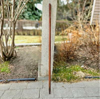
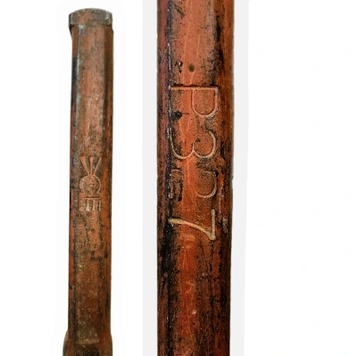
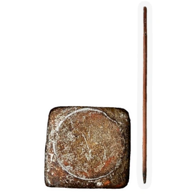
What does a survey pin look like?
Survey pins are 2cm square iron metal pins that are one metre in length. There is a pin number on the side that indicates the registration number which is used to track who placed them. The Crown is always placed north to help surveys find the pin number on the opposite side.